Sunday, July 19, 2009

Monte Cristo


In the summer of 1889, Joe Pearsall and Frank Peabody discovered a rich vein of gold and silver ore at a site soon named Monte Cristo.
Between that time and 1907 the mines produced millions of dollars in ore. A town sprang up on the peninsula between Glacier Creek and 76 Creek at the head of the South Fork Sauk River and a standard gauge railway was built to connect the mines with their smelter at Everett.

Most of the miners lived high above the town on Wilmans and Foggy Peaks, from which aerial tramways carried the minerals down the steep mountain sides to the concentrator for processing and then to the railway. At the town site were all the support services required by an isolated industrial town: a store, five hotels, a school, a newspaper and residences, mostly situated along Dumas Street or the lower area below the railway yards.

Dumas Street, in its heyday, was a 35 – 40 foot boardwalk but is now just a pathway to a town that is surrounded by 7,000 foot mountains where at one time, only the railway was the only means of transporting ore from Monte Cristo. When mining died and was replaced by tourism, the Mountain Loop Highway to Barlow Pass and a small, four mile county road from Barlow Pass to Monte Cristo replaced the railway. The county road was severely damaged by flooding in 1980 and now is gated at the pass. It is now only accessible by hiking, biking and horseback as much of the road is severely washed away and the bridge across the river is completely gone.

Monte Cristo, as a town site, was recorded on March 2, 1893 and became a Government town site on March 4, 1893.

The Kyes family played a major part in the town. After arriving in 1902 from the Klondike gold rush, they had a major interest in business and mining. To this day, descendants of the Kyes family still maintain a cabin on their property at Monte Cristo. There is also a memorial by the U.S. Naval Academy to Commander James Ellsworth Kyes, commander of the U.S.S. Leary, which was lost in 1944. Behind the memorial, there is a white picket fence that squarely surrounds a lonely fir tree that James brought down from Addison’s peak and planted as a boy in the Monte Cristo hotel’s garden in the 1920’s


Now we jump to July 18, 2009.

Joe, a fellow ghost town hunter, and I made the four mile hike into Monte Cristo. We started off from Barlow Pass at 7am. On the way to Monte Cristo, we came across the spot were you could see that we were following the railway path. Joe saw the tracks where they came out of the ground, where the path had been washed away by the river, and commented on the 18 inches of ground that covered them.

When we arrived at the town site, we snapped our first pictures of two original signs of Monte Cristo. From there, it was on to pictures of the town itself including the railway turntable, relics from the mining companies including an ore bucket, some pulleys, scrap steel, old motors, and various other items. There were also cabins that you can rent to stay in for a weekend outing. We then went further into the town up Dumas Street, taking pictures of the old buildings and the signs of where buildings once stood. Then it was on to the United Companies Concentrator. There was not much left of the concentrator, just the foundation where the once, 3 level, multistory structure once was.

We sat for a moment and took a break where the Monte Cristo hotel once stood, next to Commander Kyes’ memorial. While we were sitting, since I had been here before on two other occasions, I couldn’t help but notice the vegetation seemed to be growing around, smothering the structures of the town, and taking back what was once hers. The actual changes that I witnessed are indescribable, unless you see it first hand for yourself.


Joe crossing crudely made bridge


Remains of United Companies Concentrator


A reminder of a mining community


Houses along Dumas Street


Gas powered railway car (circa 1920)

Friday, July 3, 2009

Meeting Fellow GT Hunters


(The river from the newly built bridge/Joe and Darin at Big Four)


Today we started out to the Big Four Ice Caves up on the Mountain Loop Highway. We wanted to get there between 9 and 10AM...we got there at 10:00. Joe had already hiked in to where the ice caves are and was on his way back when we met up with him. He said it was a little hazy up there and that the ice caves haven't formed yet, it was all just still snow. So we hiked back to the vehicles and had a splendid time just chatting with each other.

Meeting up with fellow ghost town hunters is fun and definately guarenteed a great time for all.

We parted ways after pictures were taken, but the memories of meeting a fellow ghost town hunter will last a lifetime.

Wednesday, July 1, 2009

The Mountain Loop Highway


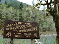
Ghost towns can be found in many places. On this trip we went up to the Mountain Loop Highway, about 15 miles from us, and found remnants of ghost towns. These were classified as "Class A to B" and "Class D" ghost towns. First we'll visit the "Class A to B" ghost towns. First is a shingle factory that was only in operation for a year, but produced enough shingles to cover 1,000 houses. The only thing left in this area are a couple of concrete slabs that held the boiler that ran the mill. Next is Marble Pass. The "45 Mine Tram" haulled ore in this area from one side of the mountain down to a mill about three miles away. And last is the Speary Iverson Mine. Covered by fallen trees, the mine is a little hard to get to. Once you get passed the trees, the mine is even harder to get to due to the steel gate that covers its enterance. But back in the day, two men, Mr. Speary and Mr. Iverson lived above the mine's enterance and worked the mine themselves.
Showing just a little rubble and no population in the area is what gives these three their classification.


The town of Silverton is a "Class D" ghost town. It has a small resident population, but still thrives to this day. Silverton is a town that still has an active charter though it is concidered a community and not a town.

Ghost Towns in Okanogan County


We hit a number of ghost towns to finish our tour of the Okanogan County area. these include Riverside, Loomis, Conconully, Ruby, Bodie, Old Bodie, Wauconda, Old Wauconda, Gold Hill, Night Hawk, and in Ferry County, Republic.


Riverside, Loomis, Wauconda, and Night Hawk are "Class E" ghost towns with somewhat less of a population than that of it's boom town years.


Ruby, Old Wauconda, and Old Bodie are a "Class A" to a "Class B" ghost towns with nothing but a sign to state that "this is where the town once stood", to a ruin or two barely standing.


Saturday, we checked in to our motel in Omak, and then we checked out the town of Riverside to view the bullet holes in the old saloon which is now a little convenience store/gas station. the holes are there, but there was some questionabillity about where they actually came from according to the person behind the counter. I guess they want to keep that a mystery, but legend has it that Frank Watkins, an outlaw of that part was there drinking and got into a scuffle with the bartender for cutting him off. So Frank pulled out his pistol and shot three rounds into the ceiling and got another drink. We figured that the town wanted to keep that part a mystery of Riverside for all the visitors that come in. Frank was killed in the Riverside livery stable and when it was time to bury him, the residents of the town voted not to put him in the cemetary. He is burried a couple hundered feet on the backside of the cemetary.


Sunday was a drive to Loomis and Gold Hill. When we got to Loomis, it was Sunday and everything was closed, even the restaraunt. The town pretty much closes down for church services and the only thing open was the gas station so we got directions from them to get to Gold Hill and pushed on.


Gold hill had nothing there but did find a back road to Night Hawk so we stopped to take some pictures of that area and then drove back.


We also stopped in at Conconully (originally called Salmon City) and had a fabulous lunch there. Afterwards, we went to the Museum where we talked with one of the caretakers there about the area and where Ruby was located. (A special note of thanks to Bonnie for the perfect directions and wonderful hospitality while at the museum.)


Monday, we headed out for Wauconda, Bodie, and Republic. These towns were easy to find as they were literally on the side of the road. Wauconda is just a gas station, store and restaraunt and is located at the junction of going to Republic, or turning off and going to Bodie. We drove through and went to Republic first and had lunch there at the Mexican restaraunt, visited the museum and took some pictures. We then headed back to Wauconda, visited the area there and then headed off to Bodie. Bodie is a "Class C" ghost town with eight buildings, including the old hotel, livery stable, some houses and two out houses, one of which is still usable.


Here are a couple of videos that we took.

One is of a deer in Conconully. Residents of Conconully have little troughs out in their yards where the deer can come up and feed. This one had to jump a fence.

The other is of the first log cabin built in Ferry County in the town of Republic, Washington.


Our last stop was the town of Okanogan, not a ghost town, but a town of great historical importance. We stopped there to visit the museum. It also pays homage to the first photographer in Okanogan County, Frank S. Matsura.